Low-power GPS: Abeeway patented technology

With advanced location-solving algorithms, the Abeeway platform and trackers bring you geolocation intelligence fit for many existing and new use cases. Usual trackers typically need long synchronization time to GPS signals resulting to extended power-consuming receive time. Meanwhile, Abeeway trackers only need a few seconds. Our better quality of service, extended battery life, and smartly configured multimodal behavior gives you all the reliability and versatility you need. 

Take a closer look at our breakthrough LP-GPS technology to understand how we achieved that!

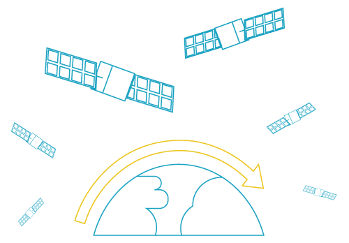
GPS (Global Position System) is the most widely used Global Navigation Satellite System to provide continuous positioning and timing information data. GPS is a constellation of satellites continuously broadcasting a radio signal containing satellite status, clock information, ephemeris data giving accurate satellite position and almanac defining the orbits of all satellites.   

A GPS receiver intercepts signals from visible satellites to determine how far away each satellite are. Those distances combined with the ephemeris data allow the calculation of the position of the receiver using the technique called “trilateration”. At a minimum, four satellites must be in view of the receiver for it to compute four unknown quantities: latitude, longitude, altitude and clock deviation from satellite time. In a typical GPS device, all the processing is made by the chipset, which requires a lot of processing time and therefore energy. 

LOW-POWER GPS: How does it work? 

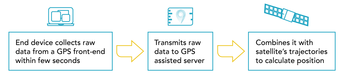
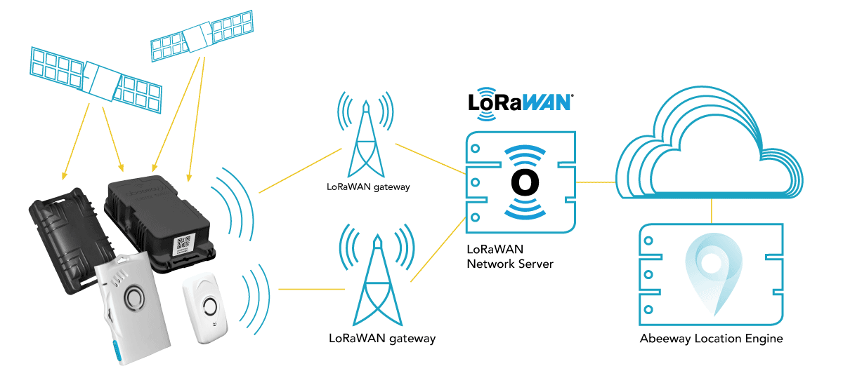
With Low Power GPS technology, the tracker only collects raw data from satellites, then transmits it to Abeeway’s geolocation server through the LPWAN (e.g. LoRAWAN) network. The server combines this information with known satellite trajectories to calculate the final position. The data on the ephemerids and the almanac is already available in the server and does not have to be collected by the device saving significant power for the tracker by improving the time to acquire GPS signal.  Therefore, the whole processing is made “in the cloud”, which is much faster than inside the device, and does not waste its energy for calculation. 

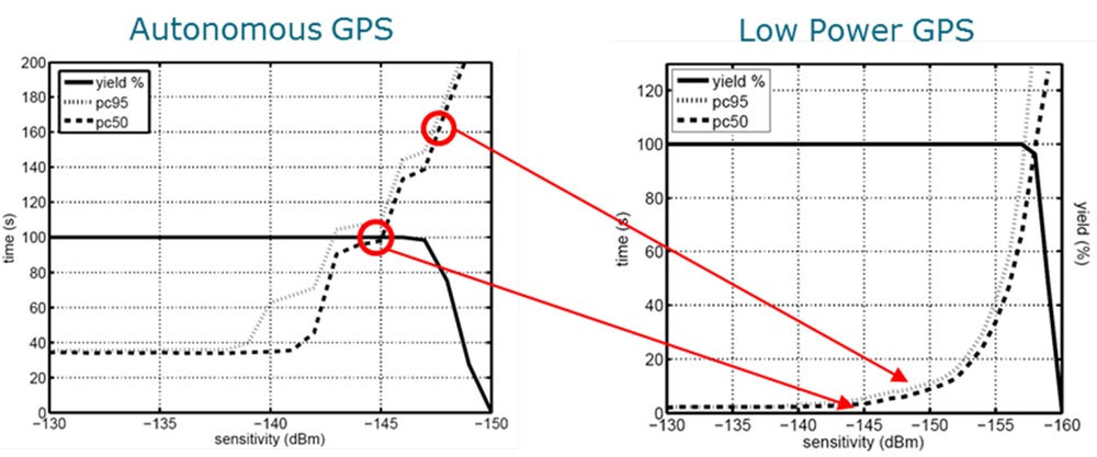
On asynchronous networks such as LoRaWAN networks, the transmission delay is deterministic: Abeeway patented LP-GPS algorithm leverages the network time information to compute positions with only 3 satellites, further enhancing success rates and further improving Time-to-First Fix and energy consumption.

Abeeway Low-Power GPS Architechture 

  1. Tracker intercepts GPS signals from visible satellites  
  2. Tracker transmits compressed data collected from a GPS front-end to GPS assitance server through Lora network (& LoRa MAC Server) 
  3. GPS assistance server performs location calculation through different steps (before sending the results to Abeeway Application Server):
  • Processing Ephemeris stage  
  • Computing Position stage  
  • Satellite clock correction  
  • Post-processing and filtering stage

LOW POWER GPS VS. GPS 

  • In good conditions, a Low Power GPS device can have a first fix under a few seconds with the same precision as a standard GPS device, which may require at least 1 min Time To First Fix (TTFF). With the Low Power GPS technique, the GPS chipset does not need to collect the ephemeris data. It is already available on the geolocation server which makes the calculation possible directly after receiving the payloads. That allows an important gain of time.  
  • In difficult conditions, which means under poor signal, Low Power GPS positioning consumes less and works better than GPS. Why? A GPS chipset needs a very good signal to collect ephemeris indispensable for a first fix. With a poor signal it’s very difficult to capture ephemeris, so a regular GPS receiver will spend a lot of energy struggling to collect it, and most likely fail to do so. Even considering that Low Power GPS may need one additional satellite compared to GPS, when the radio signals from satellites are weak – it does not make a difference because the GPS fails to give a position at all, while the Low Power GPS will provide a position. Since the ephemeris is already on the server, Low Power GPS technology does not need a strong signal to give a position. Its accuracy will depend on the signal, but at least the Low Power GPS will allow to locate the device with a maximum error of 50m.  
  • Low Power GPS hugely increases GPS performance:  power consumption is reduced by a factor of 5 to 10 depending on signal conditions, due to massive reduction of the TTFF (Time To First Fix).  
  • GPS signals are already very weak when they arrive at the Earth’s surface. The GPS satellites only transmit 27 W (14.3 dBW) from a distance of 20,200 km in orbit above the Earth. By the time the signals arrive at the user’s receiver, they are typically as weak as −160 dBW. Outdoors, GPS signals are typically around the −155 dBW level (−125 dBm). The sensitivity of a GPS it’s its ability to extract and calculate a position from a signal. Let’s check the following graphs:  
  • A regular autonomous GPS has a cold start TTFF of 40 seconds in the best case (signal above -140 dBm).  That means that it will consume energy during 40 seconds before giving a position. And at -147 dBm, the GPS just cannot get a fix anymore.  
  • Low Power GPS, on the opposite, can provide a fix under 5 seconds in the sale conditions, but continues to function with much weaker signals as low as  -155 dbm. LP-GPS is much more robust in bad weather condtions, and also converges much faster than GPS in cold start conditions, e.g. for every indoor-outdoor location use cases.  
  • Consequently, Low Power GPS provides better coverage than for GPS: all areas with a weak signal which a regular GPS is unable to use could be considered as “uncovered” for it. But since Low Power GPS can still successfully operate in them, its coverage is extended.  Low Power GPS is working in daylight indoors where GPS cannot find a position after power up.
     
  • GPS and LP-GPS are not mutually exclusive, for example when an asset is stored in a warehouse and is transported outdoors, the first fix will be obtained in a few seconds using LP-GPS, but after some time outside, the GPS will be fully bootstrapped (“hot”) and then the tracker can continue using regular local GPS (e.g., to average multiple positions internally before each LPWAN transmission) or continue with LP-GPS depending on configuration. 
  • Abeeway’s solution does not require downlink messages, which means that once the server processed the data and calculated positions, it does not need to communicate anything back to the device. That saves additional energy to the device.  

  • Abeeway Location engine leverages a multi-technology fusion algorithm, which will dynamically switch between LP-GPS, GPS, WiFi and BLE geolocation mode and seamlessly provide a position at the lowest possible energy cost. 

Example of multimode tracker: GPS – LP GPS – WIFI 

Test drive using a tracker reporting successive positions with GPS/LP GPS/WIFI. It shows that in urban area Low Power GPS is far superior than GPS. The tracker was initially placed in a car parked underground. The regular GPS was able to give a first fix after about 20 minutes, during that period LP-GPS and WiFi sniffing achieved more than a dozen fixes.

tracking-map
3-benefits

ThingPark® Location: Actility’s integrated modular location engine for Abeeway multi-technology low-power trackers 

Abeeway Location Engine, which leverages multiple geolocation technologies, including LP-GPS, is integrated into Actility’s ThingPark® Location, which is an ideal solution for your IoT tracking use cases. It combines low power communication using LoRaWAN®, with advanced location solving algorithms and low power location technologies using Wifi and GPS with patented optimization for low power IoT constraints.